Hidden away up on the 4th floor of the Paris Army Museum (in Les Invalides) is the rather unexcitingly-named Musée de Plans-Reliefs. Up here in the dark is a collection of strategic dioramas dating back some 350 years. French King Louis XIV created a workshop to build these 1:600 sale models of the major fortifications around the French coast as a tool for planning military actions. Napoleon resumed the practice in the 1800s, and today the collection includes some 100 different models. Not all of these are on display, but they are quite large and intricately detailed. Truly a hidden gem of military history in the attic of the museum. If you have an opportunity to visit the Paris Musée de l’Armée, don’t miss the chance to take an hour or so to see these!
Ammunition
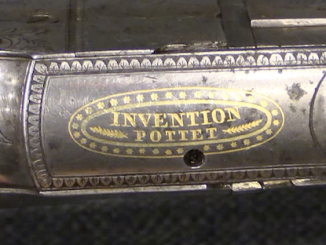
Clement Pottet: Father of the Shotgun Shell
Clement Pottet was one of the original fathers of the modern shotgun shell. He took the work of men like Pauly and developed a paper-walled, metallic-base shell for shotgun use. He had two main French […]

Prototype
CEAM 1950B: A Roller-Delayed Missing Link in .30 Carbine
At the end of World War Two, the Mauser factory complex was in the French occupation zone, and more than a few Mauser engineers went to work for the French. Among them were Ludwig Vorgimmler […]
Antiques
1854 Treuille de Beaulieu: Open-Bolt Pinfire for the Imperial Guard
The Mousqueton Modele 1854, named for General Antoine Hector Thésée Treuille de Beaulieu, was the first breechloader adopted by the French military. It was issued to the Cent Gardes (personal bodyguard) of Emperor Napoleon III […]
These were on display at Disneyland Paris, too–for a while. I don’t know if they’re still there.
This is an excellent addition to overall armaments topic. It is not just what you fight with, but in what space you fight, to put it in rudimentary terms. Yes, French and other European nations developed early in history rather meticulous methods to construct significant projects, not just for defense purposes. Ian correctly points out that they had often multiple functions.
Prior to invention of visual prospective builders used scale down models, at which they verified proportions and static strength. This is how cathedrals of old continent were built. Real break-through had been projection of 3-d objects into 2-d projection planes pioneered by G. Monge in 2nd half of 18th century.
http://tolerancing.net/engineering-drawing/engineering-drawing-history.html
This method was kept secret for long time.
Now all we need are soldier figurines to man the battle stations just to see if the positions are viable… just kidding!
You can get 1/600 scale photoetched figures for ship models and such. I don’t see why those wouldn’t work.
cheers
eon
Yet, funny thing is that many of those fortifications were demolished in several hours of shelling. How long it took for Sumter to surrender?
https://en.wikipedia.org/wiki/Fort_Sumter
No wonder it was made out of bricks 🙂
There is a good reason why stone castles and brick buildings don’t last too long during artillery sieges. The reason that attackers use artillery is because “storming the castle” would result in losing too many soldiers!
Pretty sophisticated surveying and map making techniques existed at that time, so they did not need to rely simply on painting and recollections. Very cool.
Cf. https://www.bac-lac.gc.ca/eng/discover/exploration-settlement/pathfinders-passageways/Pages/mapmakers-essay.aspx#ex2
“In New France, Champlain prepared the first chart of the Atlantic coast to Cape Cod between 1604 and 1607, including potential harbours, using triangulation. From the first of two anchorages he would take compass bearings of a series of prominent features, then move his boat over a carefully measured distance to the second anchorage and take a second set of bearings of the same features. Each feature was now at the apex of a triangle of which he had the three interior angles and the length of one side. Triangles produced this way were transferred to a chart and the shoreline sketched in. Champlain did not understand trigonometry, but later mapmakers who did used the same principles and were able to make their maps more accurate than his.”
This technique actually dates back to China in the 5th century AD. Relief maps carved in wood were made as large as ten feet square, separated into sections for easy transport.
In 1086 AD (twenty years after the Norman Conquest of England), Shen Kua, a Chinese scientist and cartographer, made a sectional contour map of of the northern frontier areas while he was surveying them for the Emperor. After a failed attempt to use wheat flour paste and sawdust, he carved the contours in wax after first melting it and pouring it into wooden boxes; the sides came off after the wax cooled and the wooden bottom formed the base of each map section. After he returned to the capital, he duplicated the map at 2x the size of his portable version, and presented it to the Emperor. It was preserved for decades as a strategic/tactical map for campaigns along the border.
(Robert Temple, The Genius of China; 3,000 Years of Science, Discovery, and Invention. New York; Simon & Schuster, 1986, pp. 179-181.)
I wouldn’t be surprised if this was where King Louis got the idea from.
cheers
eon
Paris is my least want-to-revist city (apart from maybe Milton Keynes), and Louise XIV is one of my personal least liked historical figures, but this video makes me think I might want to suffer the thieving ignorance of Parisines for another visit. I could always stay somewhere nice and commute.
Do not blame you. French are said to be rude and Parisians twice as much. I had part of my family visiting there – for one thing, service in restaurants was dismal.
Oh yeah, my daughter is fluent in French.
The French have gotten worse as of late in more ways than one. They’re not very welcoming to foreigners after several terrorist bombings.
With one small exception… those terrorists were home-grown; although of Moroccan background (speaking of Charlie-Hebdo affair). But, raised in French education system to be sure. Same for those who acted in Belgium – again, home-grown.
To be fair, if you devote some time to place and people you find we are all very similar. If you show them basic respect (yes I do bit of bonjouring when I travel to Quebec) you have them eating from your palm. Typically, country people are the best and that’s what I found during my travel to States too.
see Amedy Coulibaly – born in France, died in France
https://en.wikipedia.org/wiki/Amedy_Coulibaly
Also, I would direct you to research ethnic minorities in French foreign legion – you will be onto mild surprise. Sure, you can say that’s why this is “foreign legion” and you will be right 🙂
But, they are sworn to French republic and no one else.
Excellent video on a neat topic. Reminds me of the lovely novel “All the Light We Cannot See.” A young blind girl learns to navigate the walled city of St. Malo using a fantastically detailed model of the city her uncle has constructed. Obviously, much more to the story, but this video reminded me of some of the descriptions. Another great look at a different side of history and arms.
Cherndog I dont really know how to reply to you without sounding like Trump but yes the people from Paris are impolite to visitors although they are better now then 30 years ago.However the foreigners they dislike dont come from the west but from the south and east
Good point (and I wish Cherndog reads it too). Indeed, many East and south-east Europeans act unduly aggressive. There is lots to look at before passing judgment. What is on surface is not necessarily whole picture.
Plan relief translates to “Map in volume” so literally 3d-maps of the structures 🙂
Thanks for the highlight, this was super interesting!
Thanks for interpretation, the name on its own did not make sense to me.
Wow, these are amazing and enduring works, I’d be interested in learning the processes and skills necessary to produce these, were artists employed, cartographers, how we’re elevations so accurately reproduced, were they created prior to the use of aerial observation? So many questions